Showing posts with label civil war. Show all posts

Friday, June 14, 2013

Paces Ferry Road

Paces Ferry Road is a road in north Atlanta. It originates at Atlanta Road, near Vinings, and terminates nearby at West Paces Ferry Road. The latter continues through Buckhead, terminating at Roswell Road, where it becomes East Paces Ferry Road. Paces Ferry Road has had its name since the 1830s.

Paces Ferry Road, via Google Maps

Other Names

Variants include East Paces Ferry Road, West Paces Ferry Road, and New Paces Ferry Road.

Name Origins

Paces Ferry Road is named for Pace's Ferry, a ferry service operated by early Atlanta pioneer Hardy Pace (1785-1864). Born in North Carolina, Pace moved to north Georgia as a young man, and by the early 1830s he was operating a flat-boat ferry service across the Chattahoochee River, near Vinings. The road connecting Pace's ferry to Buckhead became known as Paces Ferry Road, and was based on the earlier route traced by the Creeks' Peachtree Trail. From Pace's ferry, the old trail continued east to a fork in Buckhead, where one branch went northeast to Toccoa, and the other veered south towards downtown Atlanta. This latter branch became known as Peachtree Road (and Peachtree Street). Atlantans looking to travel north to Chattanooga or beyond frequently traveled Paces Ferry Road by way of Peachtree Road and Buckhead.

Indian villages and trails in Fulton County, 1878
(Credit: Atlanta and Environs, via Wikimedia Commons)
Paces Ferry Road was a site of strategic importance during the Civil War. In early July, 1864, Confederate cavalry led by Gen. Joseph Wheeler defended a pontoon bridge across the Pace's ferry crossing while their comrades retreated from the Battle of Smyrna. Union troops led by Gen. Thomas Wood overwhelmed the Confederates, who attempted to burn the bridge during their retreat. When that failed, they cut the bridge ropes on their side, but it became lodged nearby. The Union soldiers crossed a few days later on boats and camped in farms along Paces Ferry Road. Hardy Pace's own home would be used as the headquarters of Union Gen. O.O. Howard.

Union soldiers crossing a river on pontoon boats
(Credit: Photographic History of the Civil War, via The Internet Archive)
The area around the road saw little development from the end of the Civil War until the early 20th century. Starting in 1904, impressive homes erected by well-to-do Atlanta citizens seeking summer refuges began dotting the landscape. That same year, an effort funded jointly by Cobb County and Fulton County to build a steel bridge across the Chattahoochee, near the landing to Pace's ferry, was completed. The bridge was renamed "Hermi's Bridge" in 1974, in memory of Hermi Alexander, who had advocated successfully to preserve it.

Hermi's Bridge in 2007
(Credit: Stephen H. Moore, via Buckhead Heritage Society)

Sources:
Buckhead Heritage Society. "Hermi's Bridge."
Garrett, Franklin M. (1954.) Atlanta and Environs, Volume I. University of Georgia Press (pp. 108-109).
GeorgiaInfo. "The Errant Pontoon Bridge: Paces Ferry." (Historical Marker)
Tuxedo Park Civic Association. "Neighborhood History."
Williford, William B. (2010). Peachtree Street, Atlanta. University of Georgia Press (pp. 1-4).

Name Sightings

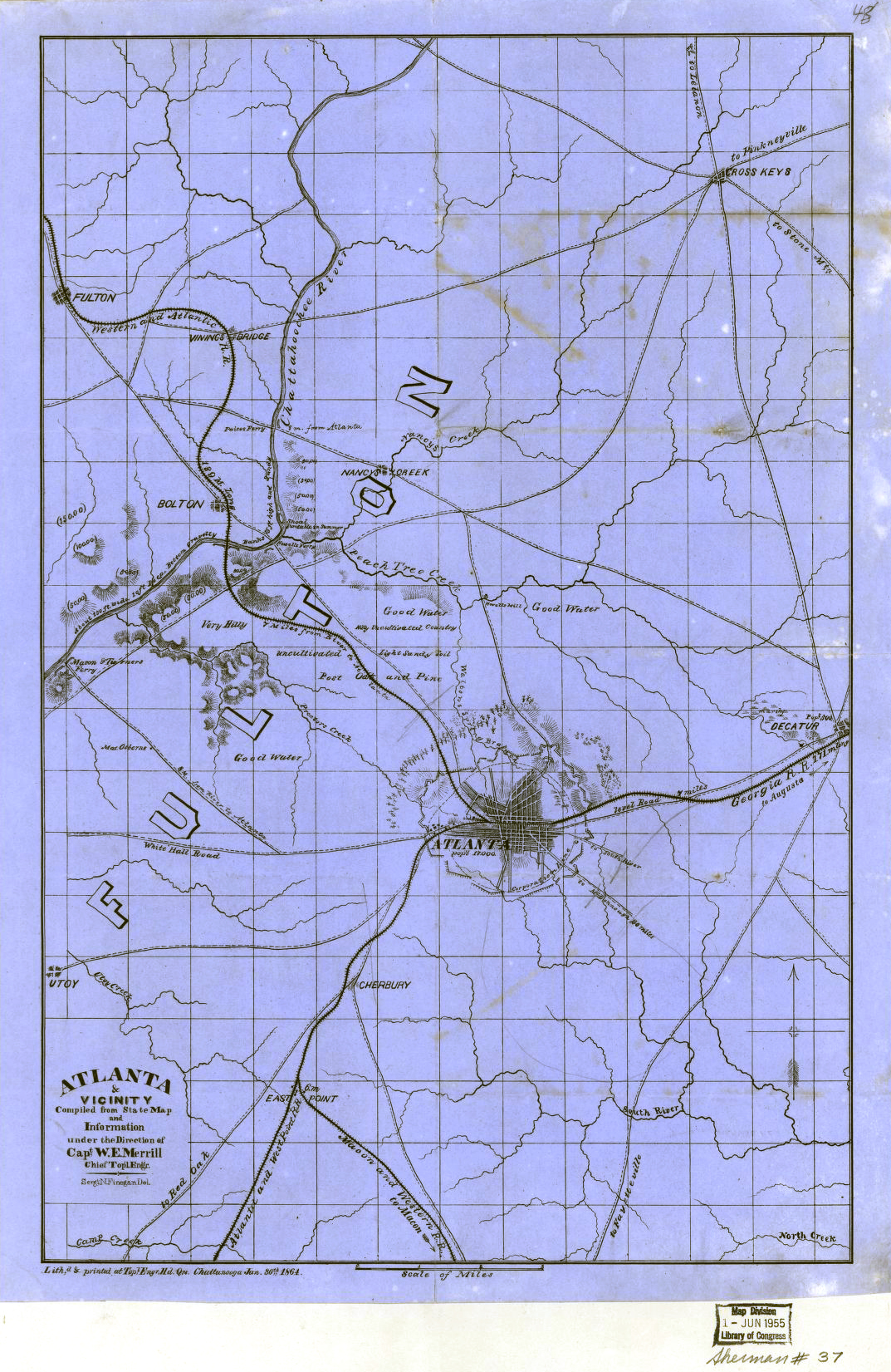
The oldest reference to Pace's ferry I can find is the 1864 "Atlanta & vicinity" map by Merrill and Finegan (courtesy of Tommy H. Jones), where it is misspelled "Paices Ferry." Since the ferry was more than 30 years old at this point, it seems likely to be found on older maps, but I haven't been able to locate any of sufficient detail. Note that Fulton County was created in 1853; prior to this, Pace's ferry was located in DeKalb County.

Related Streets

Paces Mill Road, named for Hardy Pace's gristmill

Friday, April 26, 2013

Holtzclaw Street

Holtzclaw Street is a street in Reynoldstown. It runs north-south from Kirkwood Avenue to Memorial Drive. It's had this name since at least 1913.

Holtzclaw Street on Google Maps

Other Names

None known.

Name Origins

Possibly named for James Thadeus Holtzclaw (1833-1893), an Alabama lawyer and Confederate general during the Civil War. Holtzclaw was born in Henry County, Georgia and grew up in Chambers County, Alabama. As a young man, he was accepted to West Point, but instead chose to study law in Montgomery, Alabama. After the Civil War broke out, Holtzclaw served as a lieutenant in a militia group, the Montgomery True Blues, but soon joined the Confederate Army with the same rank. He was promoted rapidly, and by the end of 1861 he held the rank of lieutenant colonel, leading the 18th Alabama Infantry.

James T. Holtzclaw
(Credit: Digital Library of Georgia)

Holtzclaw participated in numerous major battles and was wounded in at least two of them. At Shiloh (1862), he was shot through the lung and thought to be mortally wounded, but he recovered in less than two months; he also received minor injuries at Chickamauga (1863). Holtzclaw was eventually promoted to brigadier general and commanded a brigade of Alabamians under Henry Clayton's division, which was involved in the Atlanta campaign during the summer of 1864. Holtzclaw's brigade is mentioned in numerous historical markers in the Atlanta area, including one in Inman Park, directly north of Holtzclaw Street. After the Civil War, Holtzclaw returned to practicing law in Montgomery, Alabama, where he also worked as a railroad commissioner and for the Democratic party. He died and was buried in Montgomery.

Sources:
Warner, Ezra J. (1959). Generals in Gray: Lives of the Confederate Commanders. Louisiana State University Press (pp. 141-142)
Clayton's (Holtzclaw's Brigade), Ohio State University Dept. of History

Name Sightings

The earliest record we could find for Holtzclaw Street is the ACDC's 1913 Atlanta City Directory (p. 245). At that time, Holtzclaw Street extended all the way from Kirkwood Avenue to Glenwood Avenue. Today, a large industrial complex and I-20 stand in the way.

Related Streets

None yet.

Friday, March 29, 2013

Calhoun Street

Calhoun Street was a previous name for present-day Piedmont Avenue. One of Atlanta's earliest known street names, it existed from at least 1853 to 1892.

Calhoun Street in the 1850s
(Credit: 1853 Vincent map)

Other Names

Piedmont Avenue (since 1892)

Name Origins

According to Atlanta historian Franklin Garrett, Calhoun Street was named for James Montgomery Calhoun (1811-1875), a four-term mayor of Atlanta who is perhaps best known for surrendering the city to Union Gen. William T. Sherman during the Civil War.
(Credit: Pioneer Citizens' History of Atlanta)
Calhoun was born in Abbeville District, South Carolina, and by the time he was 18, both of his parents were dead. He moved to Decatur, Georgia, to live with his older brother, Ezkiel, a doctor. Calhoun chose instead to study law. In 1832, he passed the bar and married Emma Eliza Dabney (1810-1860), daughter of Judge Anderson W. Dabney of Jasper County, Georgia, and apparently "a lady of intelligence, education and refinement." They would eventually have eight children together, including William Lowndes Calhoun (1837-1908), another Atlanta mayor.

The 1830s marked the beginning of the Georgia state government's lengthy efforts to encourage white settlement and relocate Native Americans, such as the Creeks. Violence broke out when speculators sought to defraud the Creeks of their land allotments, and the so-called "Creek War of 1836" was launched. Although Calhoun was a practicing lawyer during this time, for unclear reasons he became involved in the conflict, serving as captain in an army led by Gen. William Scott and distinguishing himself in a battle near Stewart County, Georgia.

Calhoun's success as a military leader seems to have encouraged him to try his hand at politics. In 1837, Calhoun won a seat in the Georgia House, representing DeKalb County, and in 1851, he was elected a state senator. A year later, in December 1852, Calhoun moved to Atlanta, which would be his home for the rest of his life. As a lawyer and state senator, Calhoun was a prominent citizen of Atlanta. When the Civil War broke out and Atlanta was transformed into an engine of the Southern war effort, Calhoun sought an influential role. He was elected mayor in 1862, the first of four consecutive one-year terms. As the war progressed, Calhoun drew upon his military experience and organized a militia to protect the city.

Sherman and staff after the capture of Atlanta
(Credit: National Park Service)
However, the siege directed by Gen. Sherman proved to be too much for anyone, including Atlanta's Confederate protectors, who retreated on September 1, 1864. The next day, Calhoun officially surrendered the city at the corner of Peachtree Street and Alabama Street. Sherman ordered all remaining citizens to evacuate, and when Calhoun protested, gave his famous response, "War is cruelty, and you cannot refine it."

After the war, Calhoun practiced law in Atlanta with his son, Lowndes, until his death in 1875. He is buried with his wife in Atlanta's Oakland Cemetery.

Sources:
Garrett, Franklin M. (1954/2011). Atlanta and Its Environs, Volume I. University of Georgia Press. (p. 300)
Pioneer Citizens' Society of Atlanta, Pioneer Citizens' History of Atlanta, 1833-1902 (pp. 288-291)
Sherman, William T., Letter to James M. Calhoun et al.

Name Sightings

Calhoun Street appears on the earliest known street map of Atlanta, Vincent's 1853 map. It appears in city directories throughout the 1860s-80s. Its final appearance is Polk's 1891 ACD, after which it is renamed Piedmont Avenue.