Paces Ferry Road is a road in north Atlanta. It originates at Atlanta Road, near Vinings, and terminates nearby at West Paces Ferry Road. The latter continues through Buckhead, terminating at Roswell Road, where it becomes East Paces Ferry Road. Paces Ferry Road has had its name since the 1830s.
Other Names
Variants include East Paces Ferry Road, West Paces Ferry Road, and New Paces Ferry Road.
Name Origins
Paces Ferry Road is named for
Pace's Ferry, a ferry service operated by early Atlanta pioneer
Hardy Pace (1785-1864). Born in North Carolina, Pace moved to north Georgia as a young man, and by the early 1830s he was operating a flat-boat ferry service across the Chattahoochee River, near Vinings. The road connecting Pace's ferry to Buckhead became known as Paces Ferry Road, and was based on the earlier route traced by the Creeks' Peachtree Trail. From Pace's ferry, the old trail continued east to a fork in Buckhead, where one branch went northeast to Toccoa, and the other veered south towards downtown Atlanta. This latter branch became known as Peachtree Road (and Peachtree Street). Atlantans looking to travel north to Chattanooga or beyond frequently traveled Paces Ferry Road by way of Peachtree Road and Buckhead.
 |
Indian villages and trails in Fulton County, 1878
(Credit: Atlanta and Environs, via Wikimedia Commons) |
Paces Ferry Road was a site of strategic importance during the Civil War. In early July, 1864, Confederate cavalry led by
Gen. Joseph Wheeler defended a pontoon bridge across the Pace's ferry crossing while their comrades retreated from the Battle of Smyrna. Union troops led by
Gen. Thomas Wood overwhelmed the Confederates, who attempted to burn the bridge during their retreat. When that failed, they cut the bridge ropes on their side, but it became lodged nearby. The Union soldiers crossed a few days later on boats and camped in farms along Paces Ferry Road. Hardy Pace's own
home would be used as the headquarters of Union
Gen. O.O. Howard.
The area around the road saw little development from the end of the Civil War until the early 20th century. Starting in 1904, impressive homes erected by well-to-do Atlanta citizens seeking summer refuges began dotting the landscape. That same year, an effort funded jointly by Cobb County and Fulton County to build a steel bridge across the Chattahoochee, near the landing to Pace's ferry, was completed. The bridge was renamed "Hermi's Bridge" in 1974, in memory of Hermi Alexander, who had advocated successfully to preserve it.
 |
Hermi's Bridge in 2007
(Credit: Stephen H. Moore, via Buckhead Heritage Society) |
Sources:
Buckhead Heritage Society. "
Hermi's Bridge."
Garrett, Franklin M. (1954.)
Atlanta and Environs, Volume I. University of Georgia Press (pp. 108-109).
GeorgiaInfo. "
The Errant Pontoon Bridge: Paces Ferry." (Historical Marker)
Tuxedo Park Civic Association. "
Neighborhood History."
Williford, William B. (2010).
Peachtree Street, Atlanta. University of Georgia Press (pp. 1-4).
Name Sightings
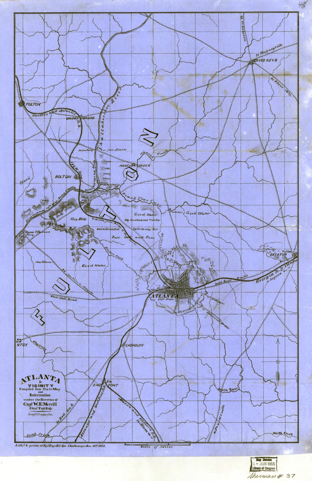
The oldest reference to Pace's ferry I can find is the
1864 "Atlanta & vicinity" map by Merrill and Finegan (courtesy of Tommy H. Jones), where it is misspelled "Paices Ferry." Since the ferry was more than 30 years old at this point, it seems likely to be found on older maps, but I haven't been able to locate any of sufficient detail. Note that Fulton County was created in 1853; prior to this, Pace's ferry was located in DeKalb County.
Related Streets
Paces Mill Road, named for Hardy Pace's gristmill


No comments:
Post a Comment